Excavations at Capel Teilo, Kidwelly, 1966–1969
G. R. JONES
William Hill (Bill)
Morris stimulated a renewed interest in the investigation and recording
of archaeological sites from the Prehistoric to the Industrial eras
in Carmarthenshire, over a period of some twenty years from 1960.1
He supervised and recorded these amateur 'digs' without the benefit of a
training in practical archaeology, aided by a number of university students
and secondary school pupils who had been imbued with his own fascination
for local history. Capel Teilo was one such site.
HISTORICAL EVIDENCE AND LOCATION
The RCAHM Carmarthenshire Inventory, referring to the visit
in 1912, dryly recorded that:
This is the site of a small chapel on the northern boundary
of the parish [of Penbre], of which it is said that traces were to be
seen a few years ago. Stones have been carted from the spot, and not a
vestige of building now remains. Within a few yards to the south was a
spring called Pistyll Teilo.2
The earliest written reference to 'Chappel Tylo' near Pistyll
Teilo in Kidwelly parish was in 1593, and the name appeared in several
further references to the locality contained in the Muddlescombe Estate
papers during the seventeenth century.3 The location
of Capel Teilo was marked in a corresponding position on Saxton's Map
of Carmarthenshire of 1578 by the symbol representing a church or chapel
and on later seventeenth century maps.4 It was shown
with a church symbol on Bowen's Map of 17295 but had
disappeared from the maps c.1750 and was ruinous by 1762.6
Subsequently it was shown inaccurately on the site of the now ruined dwelling
Ty Capel Teilo located at the roadside 300 yards to the west of the chapel.7
The location of Pistyll Teilo was added later8 but both
sides were omitted altogether on the 1957 Ordnance Survey map.9
Tales of 'Old St. Teilo's Church' and the nearby spring
still survived in local folklore in the mid nineteenth century.10
The site was not considered to merit a visit by 190011
though the dimensions of the chapel were then still discernible as crude
and ruinous walls.12-14 It is likely that over the years
stones from Capel Teilo were incorporated into the nearby buildings of
Ty Capel Teilo (now ruinous), Morfa Bach, which moved to its present site
about 1850, and Caegwyllt which is possibly the site of the former mansion
of Pengwern Uchaf.15
By the early 1950s the chapel site was thickly covered
by bushes and saplings,an abandoned corner at the east end of the field
contiguous with which was the adjacent wilderness of Cwm Teilo. An attempt
by the late J. F. Jones (former Curator, Carmarthen Museum) to rediscover
the site of the chapel building using dynamite proved unrewarding! In
Spring 1966 Mr Smith of Cae Gwyllt Farm attempted to reclaim this overgrown
part of the field for farming use. Having cleared away the dense overgrowth,
his efforts to plough the site were thwarted by numerous large immoveable
underlying stones. In May 1966 three large stones in alignment were located
in the inner face of a north wall. This development was noted by W. H.
Morris on one of his many regular surveillance excursions to the are.
Capel Teilo had been rediscovered.
THE SITE
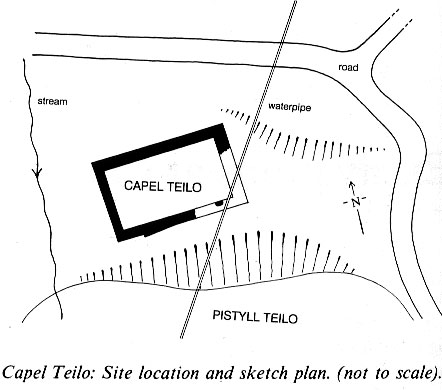
The site of the Chapel is on a spur of land on that part
of the eastern slope of Mynyddy-Garreg known as Penyfoel, on the western
side of the Gwendraeth fawr valley, some two miles eastnortheast of Kidwelly.
The remains of the building lie 200 feet above sea level at the head of
Cwm Teilo, which falls away over 50 feet immediately to the south at SN43560740. When informed of the historical importance of the site
the farmer readily consented to an excavation. This was carried out by
members of the Carmarthenshire Antiquarian Society and friends, under
the direction of W. H. Morris during the spring and summer seasons from
1966 to 1969. Notes on the progress of the work are contained in his day
book.16
THE CHAPEL
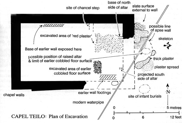
The Chapel was a simple rectangular building measuring
26 feet by 15 feet internally. The land fell significantly towards the
west through the building, which was orientated east-west. The walls were
about 2½ feet thick, with moderate sized undressed facing stones
inside and out, in a matrix of rubble, plaster and smaller stones. There
were no dressed stone fragments on the site. A foundation course had been
laid external to the south wall. No structural division existed between
nave and chancel walls.
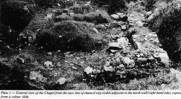
These walls had survived to a height of only two or three
courses above the footings. The best-preserved section was the north wall,
and the northeast corner in particular. Much of the east and south walls
had been robbed apart from one large internal facing stone near the southeast
corner. The floor which lay one foot below the exterior ground level was
formed of irregular flat, mediumsized stone laid on clay and was level
with the wall footing inside the northeast corner. No trace of windows
or door-way survived but presumably the entrance been through the west
wall. Numerous broken slates and fragments of ridge tiles on the site
suggested that the roof had been of that construction.
A crude step of white stones was sited about 8 feet from
the east wall, and extended for 3 feet from the north wall. The footing
of the altar on its north side was consistent with an altar width of 7
feet, assuming symmetry. A layer of plaster extended west from the altar
appeared to have formed the chancel floor.
Outside the east wall and northeast corner there was a
layer of loose cockleshell mortar several inches thick which extended
irregularly for 4 or 5 feet eastwards. Its purpose presumably to prevent
water seepage into the building from the higher ground. This area been
cut across by a modern water-pipe. Beneath the mortar layer and set adjacent
to the wall footing at the northeast corner were larger flat slabs of
slate, set irregularly and up to three deep. This layer extended for 2
or 3 feet from the wall with smaller slates lying beyond fading at about
6 feet from the east wall. There was no mortar associated with this slate
layer. The outside the north wall was not investigated. The areas external
to the south and west walls described below.
The rough walls of undressed stone in a building with an
internal width of only 15 feet suggested a twelfth or early thirteenth
century date. The ridge tile fragments were probably thirteenth to fifteenth
century, in keeping with later improvements supported by the presence
of a 7 foot wide altar and chancel step.17 EVIDENCE FOR AN EARLIER BUILDING
Beneath the Chapel floor of irregular flat slabs, which
were laid on 6 inches of yellow clay, was a firm surface of small, wellset
cobblestones. This surface extended beyond the line of the robbed out
west wall, where there were traces of what might have been a raised altar17
and an apse. This lower floor also extended along the north and west walls
of the Chapel.
Remains of an earlier wall were found partly overlain by
the later north wall. On the south side the earlier wall was about 2 foot
thick and ran immediately inside the course of the later south wall. No
mortar was associated with this stonework.
Outside the south walls there was an ill-defined surface
of small irregular stones set in clay, fading towards the edge of the
Cwm. To the west of the Chapel on a level some 6 inches below the wall
footing was a well defined surface of irregular grey stones firmly set
on clay, which extended westwards under the bed of the stream (dry during
summertime). It was not clear whether this was a natural or man-made surface.
There was a suggestion that the field hedge to the north
and east of the Chapel may originally have been part of a bank which encircled
the site.17 THE BURIALS
The skeleton of a male aged about 15 years was found beyond
the mortar layer, to the east of the Chapel in a shallow grave. The burial
was orientated facing east with the arms folded on the chest. The bones
were soft and poorly preserved, the spine, pelvis and legs being no longer
discernable. Overlaying the chest was a single copper button of eighteenth
century date presumably belonging to a cloak, as no other buttons were
found. Immediately surrounding the skeleton was an indeterminate blackish
layer, perhaps the remains of textile.
The skeletons of three or more infants were also uncovered
near the southeast corner of the Chapel, buried superficially and in close
proximity, not orientated. There were no gravestones on the site and no
burials were discovered inside the Chapel.
It was not customary for burials to take place other than
at the parish church until the nineteenth century. The isolated burials
at Capel Teilo imply a continued veneration being accorded to the site.
The young man may have died by drowning or suicide, while the infants
may have been stillbirths or neonatal deaths.
THE FINDS
Numerous finds of North Devon 'gravel-tempered' ware, 'sgraffito'
plate, slip ware posset pot and other miscellaneous redware sherds of
seventeenth to eighteenth century date were found both inside and outside
the building. Similar types were found at Kidwelly Castle. These North
Devon wares from the kilns of the Barnstaple-Bideford area were traded
extensively along the south Wales coast and far beyond.18
The ridge tile sherds, some with shallow, lopsided crests
were of thirteenth-fifteenth century date.18 A Charles
II farthing (1672-9 type) was found on the later floor inside the south
wall. A variety of Victorian and later china fragments were found superficially
within the Chapel. There were cockleshells in the eastern sections of
the excavation but very few animal bones were found, and there was no
evidence of fires.
PISTYLL TEILO
This was noted in references to nearby 'Chappell Tylo'
in 1593 and 1622.19 Though the two were clearly associated
they were not co-located. At the end of the nineteenth century steps led
down from the field to Pistyll Teilo, though no trace of these now remains.
The water was said to be especially good for rheumatism and sprains.19
Legend refers to a ghost which formerly haunted this spot and cried in
pitiful tones:
Mae'n hir ac yn o'r i ares The site of the spring was not investigated during the excavations as
it was completely overgrown and inaccessible at that time.
POSTSCRIPT
In recent years the Chapel site has been filled in and
a new entrance made into the field opposite the farm lane leading to CaeGwyllt.
The trees and bushes on the north rim of Cwm Teilo have been cut down
exposing the site, and is again under grass. The large stone which forms
the northeast corner of the Chapel building is still visible on the surface
however, which will allow orientation for astute visitors to the site.
ACKNOWLEDGEMENTS
My thanks are due to Terry and Heather James who provided
me with the opportunity to write this article, and who waited patiently
for the draft version and have helped prepare the illustrations. Also
those colleagues who toiled away with me on that quiet hillside in an
earnest attempt to discover the secrets of Capel Teilo. Finally, to the
late Bill Morris himself, who gave us all so much insight and understanding
of local history.
NOTES
I orwyr Wil Wattar20
1.
H. James, 'W. H. Morris A Memoir', Carms. Antiq., vol XXV, 1989,
pp. 38.
2. An Inventory of the Ancient Monuments in Wales and
Monmouthshire, Vol. V, Carmarthenshire, HMSO 1917, no. 686 p.232.
3. National Library of Wales, Muddlescombe Deeds.
4. C. Saxton, A Map of the Counties of Radnor, Brecknock,
Cardigan and Carmarthen in his Atlas of England, 1578, marks
Capel Teilo, as does J. Speed on his map in Theatre of the Empire of
Great Britaine 1676,basically a copy of Saxton. See discussion of
these map sources in T. A. James, 'Where Sea Meets Land', in this volume.
5. Emanuel Bowen Map of South Wales, 1729.
6. marked only as 'Tylo' on T. Kitchen's A New Map
of Carmarthenshire 1764.
7.Surveyors' original drawings at 2 inches to the mile
for first edn. OS one inch maps, 1811-1820, photocopies in NLW.
8. First Edition, Sheet 41, Carmarthenshire, one inch
OS, 1831.
9. OS Sheet SN 40 Burry Port, 1:25000, 1957.
10. J. Morgan, Trans. Carms. Antiq. Soc, vol 1,
1905-6, p. 66.
11. H. C. Tierney, A Guide to Ferryside, Carmarthen
1905.
12. H. C. Tierney, 'A Forgotten Chapel in Carmarthenshire',
Trans Carms. Antiq. Soc., vol. 1, 1905-6, pp 59-60.
13. H. C. Tierney, 'Five ruinous chapels within the marsh:
Tylo, Llanfihangel, Coker, Cadoc and Thomas', Trans. Carms. Antiq.
Soc. vol 2, 1906-7, p. 152.
14. D. D. Jones, A History of Kidwelly, Carmarthen,
1908.
15. T. Beynon, Allt Cunedda, Llechdwnni a Mwdlwscwm,
Aberystwyth.
16. W . H. Morris, Day Book 1966-69, Carmarthen Record
Office.
17. C. A. R. Ralegh Radford, pers. comm. on site visit,
1968.
18. J. M. Lewis, pers. comm. on site visit, 1968.
19. F. Jones, The Holy Wells of Wales, 1954, p.
27 & 164.
20. G. Evans, 'Carmarthenshire Gleanings', Trans Soc.
Cymmrodorion, vol. XXV, 1915, p. 106.